
Spider Ranch Rd ~ Santa Maria Mtns. AZ
 08-30-2004, 07:31 AM
#1
Contributing Member
Thread Starter
Join Date: Nov 2002
Location: Prescott, AZ
Posts: 644
Likes: 0
Received 0 Likes
on
0 Posts
Spider Ranch Rd ~ Santa Maria Mtns. AZ
Crawler#976 invited me on a trip to do a road that I had never been on - the Spider Ranch Road. It's possible that access through a portion of it may get closed, so we figured we better do it while we can. It was a beautiful trip! Lots of granite boulders, just the way I like it. From this road we went on to traverse a good chunk of the Santa Maria mountains in Arizona. It was topped off with a gorgeous full moonrise. We probably logged somewhere around 70 miles of dirt trails and roads (I haven't messed with the GPS track yet). There is a wilderness area in these mountains that has me very intrigued, and I can't wait to get my backpack and get in there. (Apache creek wilderness).
Here is the TRIP GALLERY
Thanks for the great trip Mark!
Here is the TRIP GALLERY
Thanks for the great trip Mark!
 08-30-2004, 08:17 AM
#2
Registered User
Join Date: Apr 2003
Location: Chino Valley, Az.
Posts: 938
Likes: 0
Received 0 Likes
on
0 Posts
Thanks Chris! Glad we were able to get thru.
Back to basic's wheelin'- I enjoy trail riding/exploration more than the crawlin'.
I was whupped- a lot of miles of dirt roadin' and typical AZ mesa top trails.
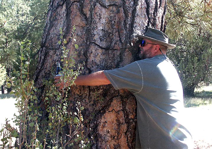
The "Big Tree" was listed on the National Register of Big Trees as the largest Ponerosa Pine in AZ. It stood 120'+ tall, and was 16' 10-3/4" in circumference. One of my buddy's climbed it..........
http://www.arizonensis.org/bigtrees/arizona_champs.html
Check for record trees in your area- pretty neat to see'm
http://www.americanforests.org/resou...rees/index.php
Back to basic's wheelin'- I enjoy trail riding/exploration more than the crawlin'.
I was whupped- a lot of miles of dirt roadin' and typical AZ mesa top trails.
The "Big Tree" was listed on the National Register of Big Trees as the largest Ponerosa Pine in AZ. It stood 120'+ tall, and was 16' 10-3/4" in circumference. One of my buddy's climbed it..........
http://www.arizonensis.org/bigtrees/arizona_champs.html
Check for record trees in your area- pretty neat to see'm
http://www.americanforests.org/resou...rees/index.php
Last edited by crawler#976; 08-30-2004 at 08:25 AM.
08-30-2004, 08:43 AM
#3
Contributing Member
Join Date: Jun 2002
Posts: 1,031
Likes: 0
Received 0 Likes
on
0 Posts
Looks like a nice trip, gents. Chris, I'm a sucker for pics of the earth's shadow, and I like the one of yours with the moon. If you crop it to the base of the mountains, it would be even better! Mark, looks like you can put on a good light show, too!
I'd go out driving with you guys anytime. We'll have to get together at some point. I haven't mentioned it previously, but my best friend since grade school actually lives in Paulden, just north of you guys. Next time I'm in the area (not sure when), we'll have to hook up.
I'd go out driving with you guys anytime. We'll have to get together at some point. I haven't mentioned it previously, but my best friend since grade school actually lives in Paulden, just north of you guys. Next time I'm in the area (not sure when), we'll have to hook up.
08-30-2004, 09:02 AM
#4
Registered User
Join Date: Apr 2003
Location: Chino Valley, Az.
Posts: 938
Likes: 0
Received 0 Likes
on
0 Posts
Originally Posted by Darren
I'd go out driving with you guys anytime. We'll have to get together at some point. I haven't mentioned it previously, but my best friend since grade school actually lives in Paulden, just north of you guys. Next time I'm in the area (not sure when), we'll have to hook up.
08-30-2004, 11:00 AM
#5
Contributing Member
Join Date: Jun 2002
Posts: 1,031
Likes: 0
Received 0 Likes
on
0 Posts
That sounds intriguing, Mark. In fact, you really got me thinking hard about this. I have some time to use up by the end of the year and might just use some to head down your way. I'll be talking to my friend tonight anyway, and I'll check his schedule while I'm at it, but I'm thinking I could swing something in mid to late October or November easy enough.
If you would, PM me your email address, and the three of us could discuss our plans further from there. Thanks!
If you would, PM me your email address, and the three of us could discuss our plans further from there. Thanks!
08-30-2004, 11:50 AM
#6
Registered User
Join Date: Jul 2003
Location: Southern California
Posts: 2,399
Likes: 0
Received 0 Likes
on
0 Posts
That's the first good pics I've seen of your truck Mark (that avatar is a bit hard to figure out  --awesome! Do you have a gallery of pics or something?
--awesome! Do you have a gallery of pics or something?
08-30-2004, 11:55 AM
#7
Awesome pics guys. Be sure to let me know when you plan another trip that doesn't involve rocker panel mutilation. And let me know when Darren comes out too, we definitely have to take a trip!

Trending Topics
08-30-2004, 11:56 AM
#8
Registered User
Join Date: Apr 2003
Location: Chino Valley, Az.
Posts: 938
Likes: 0
Received 0 Likes
on
0 Posts
Originally Posted by FirstToy
That's the first good pics I've seen of your truck Mark (that avatar is a bit hard to figure out --awesome! Do you have a gallery of pics or something?
--awesome! Do you have a gallery of pics or something? 08-30-2004, 12:33 PM
#9
Contributing Member
Thread Starter
Join Date: Nov 2002
Location: Prescott, AZ
Posts: 644
Likes: 0
Received 0 Likes
on
0 Posts
Well, I was happy to see proof that Mark is indeed a tree hugger 
Thanks! Yea, I thought the same thing, and I did crop it... but there was just something about that dusky desert floor and the fence line that seemed to make it look better to my eye than the cropped version, so I left it. Hey, that would be awesome if you could do a trip out here with us!!
Originally Posted by Darren
...Chris, I'm a sucker for pics of the earth's shadow, and I like the one of yours with the moon. If you crop it to the base of the mountains, it would be even better!
08-30-2004, 12:42 PM
#10
Registered User
Join Date: Apr 2003
Location: Chino Valley, Az.
Posts: 938
Likes: 0
Received 0 Likes
on
0 Posts
Originally Posted by BajaTaco
Well, I was happy to see proof that Mark is indeed a tree hugger
or getting a rough estimate of it's girth- similar to mine at about 14'
08-31-2004, 01:15 PM
#12
Registered User
Join Date: Apr 2003
Location: Chino Valley, Az.
Posts: 938
Likes: 0
Received 0 Likes
on
0 Posts
It'd be a long trip for the Phx guy's, but you're welcome to come next time. We were on the trail for roughly 8 hours, not counting pavement miles. There are plenty of beautiful areas to camp over up there-
 08-31-2004, 06:17 PM
#14
Registered User
Join Date: Apr 2003
Location: PEORIA, AZ
Posts: 1,851
Likes: 0
Received 0 Likes
on
0 Posts
I have no idea where Santa Maria is. I'm guessing around the area of Prescott or the like?
You're right, eight hours on the trail plus pavement time back home is quite the day but I'm sure we would work something out to cut it a bit shorter.
Lovely scenery however. Would like to take the trip myself sometime.
Christian, you're in?
You're right, eight hours on the trail plus pavement time back home is quite the day but I'm sure we would work something out to cut it a bit shorter.
Lovely scenery however. Would like to take the trip myself sometime.
Christian, you're in?
08-31-2004, 08:11 PM
#17
Contributing Member
Join Date: Apr 2004
Location: Parker, CO
Posts: 942
Likes: 0
Received 0 Likes
on
0 Posts
Originally Posted by Darren
That sounds intriguing, Mark. In fact, you really got me thinking hard about this. I have some time to use up by the end of the year and might just use some to head down your way. I'll be talking to my friend tonight anyway, and I'll check his schedule while I'm at it, but I'm thinking I could swing something in mid to late October or November easy enough.
If you would, PM me your email address, and the three of us could discuss our plans further from there. Thanks!
If you would, PM me your email address, and the three of us could discuss our plans further from there. Thanks!
08-31-2004, 09:09 PM
#18
Registered User
Join Date: Apr 2003
Location: PEORIA, AZ
Posts: 1,851
Likes: 0
Received 0 Likes
on
0 Posts
Camping? Do not see why that can be a problem.
Cooler months are just around the corner and so is hunting season and I've got quite a few coming up this year.
I've got late OCT and all of NOV filled already.
How is everyone's schedule looking?
YODA, I would not have room, sorry.
Cooler months are just around the corner and so is hunting season and I've got quite a few coming up this year.
I've got late OCT and all of NOV filled already.
How is everyone's schedule looking?
YODA, I would not have room, sorry.
09-01-2004, 06:21 AM
#19
Registered User
Join Date: Apr 2003
Location: Chino Valley, Az.
Posts: 938
Likes: 0
Received 0 Likes
on
0 Posts
Originally Posted by KING
I have no idea where Santa Maria is. I'm guessing around the area of Prescott or the like?
You're right, eight hours on the trail plus pavement time back home is quite the day but I'm sure we would work something out to cut it a bit shorter.
Lovely scenery however. Would like to take the trip myself sometime.
Christian, you're in?
You're right, eight hours on the trail plus pavement time back home is quite the day but I'm sure we would work something out to cut it a bit shorter.
Lovely scenery however. Would like to take the trip myself sometime.
Christian, you're in?
The Santa Maria mountains are basicly due west of Chino Valley- about 40 miles from Prescott. It is a relatively small "island in the sky", a strip of higher elevation Juniper/Pinion Pine and Ponderosa Pine forest about 5 to 10 miles wide and 25+ miles long. To the north, it borders the San Luis Maria Baca Float/ORO Ranch, a 20 square mile land grant from Spanish Colonial times (closed to the public), and the Santa Maria River Canyon to the west. The eastern side is bounded by the Big Chino, a praire grass land that extends from near Seligman to near Prescott Valley. It is the head waters of the Verde River to the north, and the Agua Fria to the south. The majority of the area is part of the Prescott Nat. Forest. The only time the area is even slightly populated is during Deer/Elk season- and I generally avoid the woods during rifle season completely.
Weather wise, it's similar to Prescott at the lower end and like Flag/William's at the upper- so lows are in the 40's to upper 50's now, highs 80's to 90. It will be considerably cooler in Oct/Nov tho.
The majority of the trip Chris and I took is in a very, very remote area, with no shortcuts per say. In fact, the side roads off the route would prolly be termed "long" cuts- the one trail hasn't had a rig over it in years....other than quads and dirt bikes....I will prolly give it a try this fall, but it will require a full on trail rig to get thru. We could have turned east to Campwood at Cottonwood Creek, but you'd miss the big trees, and if you want to see Apache Creek, ya gotta come out at Walnut Creek Ranger Station instead of Campwood.
I'll be glad to lead another run up there- as long as it's not wet weather
 09-01-2004, 05:40 PM
#20
Registered User
Join Date: Apr 2003
Location: PEORIA, AZ
Posts: 1,851
Likes: 0
Received 0 Likes
on
0 Posts
Roger that, Mark.
Great description of the location.
Maybe early next year would be better off. February.. March??
I will probably end up going myself sometime from now until NOV to get a small preview of the terrain.
Great description of the location.
Maybe early next year would be better off. February.. March??
I will probably end up going myself sometime from now until NOV to get a small preview of the terrain.


